Background
The Department of Energy (DOE) Atmospheric Radiation Measurement (ARM) user facility conducts long-term observations of meteorology, clouds, aerosols, and other related systems at sites around the world. The vision of ARM is to provide researchers with “the best array of field observations and supporting state-of-the-art data analytics to significantly improve the representation of challenging atmospheric processes in earth system models.” Toward this goal, ARM generates a library of high-resolution atmospheric simulations that complement the suites of observations available at selected locations. This effort is called the Large-Eddy Simulation (LES) ARM Symbiotic Simulation and Observation (LASSO) activity.
LASSO simulations are organized into discrete “scenarios” with each scenario containing related simulations focusing on a particular location, cloud regime, or other unique identifying criteria. Two scenarios have been produced prior to LASSO-ENA. The first scenario, LASSO-ShCu, focuses on shallow convection at ARM’s Southern Great Plains atmospheric observatory in Oklahoma [Gustafson et al., 2020, Gustafson et al., 2017, Gustafson et al., 2020]. The second, LASSO-CACTI, focuses on deep convection initiation and early growth of the convection during the Cloud Aerosol and Complex Terrain Interactions (CACTI) field campaign in Argentina [Gustafson et al., 2023, Gustafson et al., 2025]. This document describes the third scenario, LASSO-ENA, that focuses on shallow maritime clouds at ARM’s Eastern North Atlantic (ENA) atmospheric observatory.
LASSO-ENA Scenario Overview
The scientific drivers for the LASSO-ENA scenario germenated during the LASSO Expansion Workshop in 2019 [Gustafson et al., 2019]. The ENA observatory has collected observations related to marine clouds since 2010, and thus has provided an important data set spanning an array of marine cloud types. Combining these data with detailed modeling could be used to address open questions around precipitation from shallow marine clouds and how clouds behave in different background environmental conditions that lead to different types of cloud organiation, such as overcast closed cells and the more localized clouds of open cells that form rings of clouds with clearer air inside the rings. The resulting scenario is configured based on these motivations.
As detailed in the remainder of this document, LASSO-ENA contains approximately 60 case dates sampled from open-cell, closed-cell, and transitional cloud conditions. The simulations use the System for Atmospheric Modeling (SAM) LES model with a doubly periodic domain [Khairoutdinov and Randall, 2003]. The primary simulations employ spectral-bin micrphysics to provide a more detailed handling of the cloud and precipitation physics, and a the aerosol sensitvity for each case is examined using a low, medium, and high aerosol suite for each case. As in the prior scenarios, the large-scale condtions are obtained from multiple sources since any single source can be less accurate on some days.
ENA Atmospheric Observatory
The ENA atmospheric observatory is one of ARM’s permanent sampling locations that also serves as a focal point for more targetted field campagns. ENA is located on Graciosa Island, which is part of the Azores archipelago in the North Atlantic Ocean, about 1400 km west of Lisbon, Portugal. Graciosa is approximately 12 km long with its highest elevation at 375 m. The specific coordinates of ENA are 39°5’29”N, 28°1’32”W on the north side of the island. The instruments are installed adjacent to the island’s airport at an elevation of 30 m. This permits clear views toward the northern sector and a clean fetch from that direction. Flow from the northern sector is generally representative of oceanic conditions.
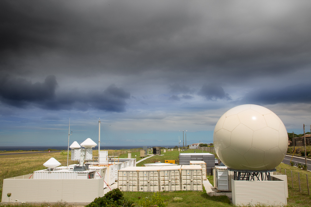
Figure 1 The ENA atmospheric observatory with the radars in the foreground and the instrument field in the distance.
Several prominant field campaigns have occurred at ENA. Of particular note is the Aerosol and Cloud Experiments in the Eastern North Atlantic (ACE-ENA) campaign that had two periods of intense sampling during 2017 and 2018 [Wang et al., 2022]. ARM’s Gulfstream-159 (G-1) airplane deployed during the summer 2017 and winter 2018 periods to sample aerosol and cloud characteristics aloft. This was combined with high uptime for the radars to provide a comprehensive suite of measurements.